Rollercoaster in °C. #MyAlaskaWX #AKwx

Joyce Bell :mastodon: 🇺🇦🇨🇦🇲🇽
boosted

KTOO: Updates as ‘unprecedented’ weather causes flooding, avalanches in Juneau (1/7/26)
KTOO: Updates as ‘unprecedented’ weather causes flooding, avalanches in Juneau (1/7/26)
Joyce Bell :mastodon: 🇺🇦🇨🇦🇲🇽
boosted
Area of known avalanche risk in downtown Juneau, Alaska... wow!
https://experience.arcgis.com/experience/140eed9c560842b0847e6ef2fef2f8a1

Area of known avalanche risk in downtown Juneau, Alaska... wow!
https://experience.arcgis.com/experience/140eed9c560842b0847e6ef2fef2f8a1
Joyce Bell :mastodon: 🇺🇦🇨🇦🇲🇽
and 1 other
boosted

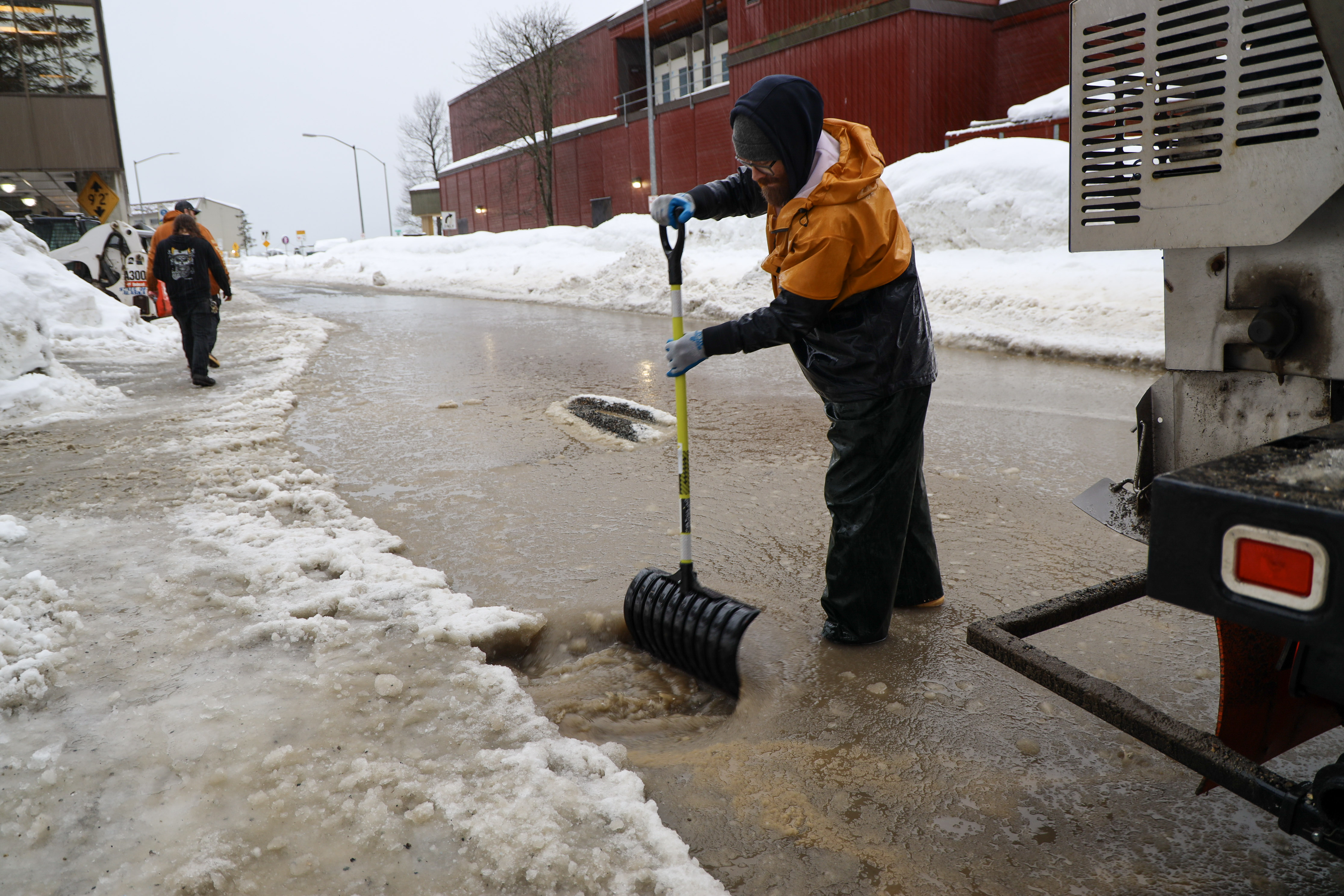
Juneau faces flooding risk as atmospheric river follows its snowiest December in more than 80 years, Alaska
After its snowiest December in more than eight decades, Juneau, Alaska, now faces flooding threats as warm Pacific air brings heavy rain over deep snow. The National Weather Service (NWS) warns that clogged drains and rapid snowmelt could trigger flooding in streets and small streams through the weekend. #weather #AR #AKwx
https://watchers.news/2026/01/09/juneau-faces-flooding-risk-as-atmospheric-river-follows-its-snowiest-december-in-more-than-80-years-alaska/
FinchHaven sfba
boosted
Avalanche evacuation for Juneau, Alaska
HIGH RISK – EVACUATION ADVISED
UPDATED FRIDAY, JANUARY 9, 2026, 10:30AM
THIS IS AN EVACUATION ADVISORY. EMERGENCY SHELTER IS AVAILABLE AT CENTENNIAL HALL. EMERGENCY RESPONSE CREWS ARE STAGED TO RESPONSE IN THE EVENT OF AN AVALANCHE.
THE POTENTIAL FOR AVALANCHES IN ALL KNOWN SLIDE PATHS CONTINUES TO INCREASE AND IS VERY LIKELY TO DUE TO INCREASED SNOWFALL, WARMER TEMPERATURES AND SEVERAL INCHES OF RAIN ANTICIPATED AT HIGH ELEVATIONS.
ADOT&PF IS CLOSING THANE ROAD AT THE AVALANCHE GATES AT 12PM (JAN 9).
Lenz Grimmer
boosted

Fairbanks cold: based on the current forecast, the 42 days from Dec 5, 2025 to Jan 15, 2026 is on track to be coldest six weeks in the Golden Heart City in more than half a century. The last time there was a colder six weeks was Dec 25, 1970 to Feb 4, 1971. @anisian @Climatologist49
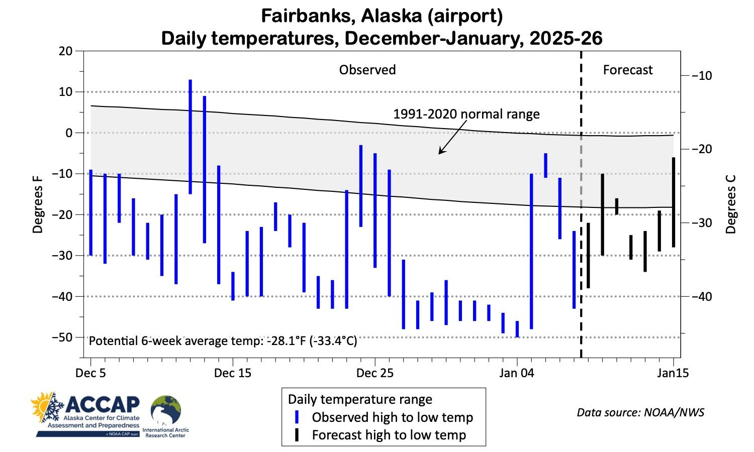
Fairbanks cold: based on the current forecast, the 42 days from Dec 5, 2025 to Jan 15, 2026 is on track to be coldest six weeks in the Golden Heart City in more than half a century. The last time there was a colder six weeks was Dec 25, 1970 to Feb 4, 1971. @anisian @Climatologist49
FinchHaven sfba
boosted

#OKwx #AKwx #MOwx #SevereWeather
Mesoscale Discussion 0008
NWS Storm Prediction Center Norman OK
0908 AM CST Thu Jan 08 2026
Areas affected...Northeast Oklahoma into adjacent portions of Missouri and Arkansas
Concerning...Tornado Watch 1...
Valid 081508Z - 081715Z
The severe weather threat for Tornado Watch 1 continues.
SUMMARY...The threat for severe wind gusts and brief tornadoes will continue into the late morning hours for northeast Oklahoma and adjacent portions of Missouri and Arkansas.
DISCUSSION...VWP observations from KINX in northeast OK depict a steady increase in low-level flow up to 50-60 knots within the 0-2 km AGL layer over the past 90 minutes. This is enlarging low-level
hodographs with 0-1 km SRH increasing upwards of 400 m2/s2 immediately preceding developing warm-advection-driven convection and the more established squall line coming out of central OK. Similarly, the KTLX VWP in central OK is sampling the passage of a 75-80 knot mid-level jet that is supporting not only intense deep-layer wind shear but also strong ascent over northeast OK. These strong kinematics should compensate for an otherwise meager thermodynamic environment (250-500 J/kg MLCAPE) and will continue to support the potential for brief tornadoes as well as severe wind gusts.
In the short term, the greatest severe wind/tornado threat will likely be associated with the more organized portion of the squall line (currently in Osage/Washington counties, OK) as it moves east/northeast over the next couple of hours. The loosely organized convection to the southeast of the Tulsa metro will likely undergo further organization with an increasing wind/tornado threat within the next couple of hours as a convective band becomes established.
..Moore.. 01/08/2026
FinchHaven sfba
boosted

5:45AM: 35F, light snow.
Well, this winter is certainly wintering more than some (most) winters I remember wintering.
Woke up to about 2" of snow and snow plows beeping. We could get up to 4" more before we are slammed with an atmospheric river that will bring 2-4" of rain in a day. That's coming directly from Hawaii...
ye olde Pineapple Express.